When I tell friends, family, or strangers about the work I’ve been doing, the reactions all tend to be something along the lines of, “wow, GIS! Sounds interesting…what is it?” I always respond with a speech that, after having recited it dozens of times, is very well rehearsed.

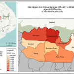
The best maps tell stories. They take us on journeys in places both familiar and strange, revealing information that might not have been evident before. They also tell these stories remarkably quickly, allowing us to gain a better understanding of situations or make decisions in short periods of time
Have you ever used GIS to analyze data? GIS — short for Geographic Information System — is a mapping tool that be used to turn datasets into useful information.
